Mark Lund (1), Helen Martin (1),
- MiWER
Historical association of wetlands and rivers in the Perth-Bunbury region
Funding: Water and Rivers Commission (Western Australia)
This is a slightly modified extract from the report – Lund, M.A. and Martin, H.C. (1996) Historical association of wetlands and rivers in the Perth-Bunbury region. Water Resource Technical Series. Water and Rivers Commission Report WRT3. Perth, Western Australia. The full report also includes information on each Shire and Suburb in the Perth-Bunbury region.
Early Exploration
The Dutch were the first Europeans to discover Western Australia (WA) in 1616 and over subsequent years mapped the coast and lost many ships to reefs. The Dutch found that the land contained little in terms of accessible supplies and the Aboriginal people were seen as `fierce savages’ (Appleyard & Manford 1979). As a result, they made no attempt to claim the land. Between the 1700s and early 1800’s both French and British explorers mapped the WA coastline, although it was a British explorer (George Vancouver) who found the best natural harbour on the coast which he named King George Sound (in present-day Albany). This provided a valuable base for more detailed explorations of the coast. The rivalry between British and French interests allowed Captain James Stirling to persuade Governor Darling of the New South Wales Colony to allow him to explore the Swan River with the intention of determining its suitability as a site for a new colony. His reports led to the eventual establishment of a British colony on the Swan River in 1829.
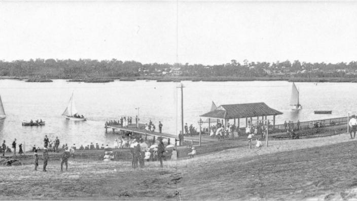
Oblique image of central Perth in 1827 created with GIS and 3D Modelling as part of WA Museum ‘Reimagining Perth’s Lost Wetlands‘ exhibition
General History of Early European Colonisation
The early settlement of Perth and other cities/towns within the region has been well documented by historians (eg. Appleyard & Manford 1979; Stannage 1981; Ewers 1971; Barker & Laurie 1992; Richards 1978). Typically in these accounts, the settlers’ use and needs in relation to water has been secondary to the political and social intrigues of the times. The publication of `Water: The abiding challenge’ by Morony (1980) has remedied this situation for Perth. The book provides a comprehensive history of water supply, drainage, and sewage in Perth. No similar histories have been written for the other cities/towns within the study area.
Captain Stirling visited the Swan River in March 1827 and spent 9 days exploring (Markey 1977). He concluded that the area was supplied with a wealth of freshwater sources, including wetlands, streams, springs and accessible groundwater. He also concluded that the climate was moderate. At the beginning of autumn, he was fortunate to find an area with ample water supplies. On his return in 1829, he located the Swan River Colony (later renamed Perth) on the northern banks of the Swan River, just east of Mount Eliza. Why he choose this particular site has been the cause for much speculation (see Markey 1977 and Seddon & Ravine 1986). The colony was surrounded to the north by ten wetlands which at times of high rainfall joined and flowed through Claise Brook to the Swan River. In the colony’s first summer, it became apparent that the wetlands were an unreliable source of water and many settlers resorted to using groundwater extracted from shallow wells. The same situation occurred in Fremantle where the two inland wetlands also proved unreliable as a water resource and were quickly filled in and built over. Once the wetlands lost their importance for a water supply they turned from assets to liabilities restricting further growth of the city and posing drainage problems.
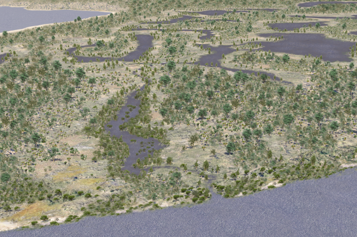
Map of the Wetlands of Perth in 1834 (CC from Wikipedia)

A timeline of water-related events in the history of the region
The following is a summary of major historic events that are related to water in the Region, although most of the information concerns Perth (based on information from Ewers 1971; Jarvis 1979; Markey 1977; Morony 1980; Parker 1983; Seddon & Ravine 1986; Tauman 1978; WAWA 1994; WAWRC 1992).
The early years – 1829 to 1839
| 1829 | Swan River Colony was founded. |
| 1829-1864 | Water for ships docking at Fremantle is obtained at a price, from the well of Mr Bateman. Water is transferred in barrels by boat |
| 1829 – 1885 | Swan River was used as the principal means of transport for both goods and passengers between Perth and Fremantle. Fremantle Trust encourages the draining and infilling of all wetlands around Fremantle. |
| 1829-1890 | Most drinking water is supplied by shallow wells, wealthier people may also have a water storage tank, otherwise, water from the drains and lakes is used. |
| 1831 | The construction of Burswood Canal allows boat passage from Fremantle, past Heirisson Island to Guildford. |
| 1832 | Henry Reverley constructs the first of the colony’s reservoirs by excavating an area of land between Mill St and William Street in Perth. The reservoir is to be used to power a mill. |
| 1833 | Agricultural output is so poor, that the colony nearly starves before supplies arrive by ship. A rival mill, built by Samuel Kingsford (on Mill St) is given perpetual rights to four of the lakes as water sources, which marked the end for Reverley’s Mill. It is also hoped that this venture would reduce the chances of flooding, but it didn’t. |
| 1834 | Wool is first exported and is an agricultural success. |
| 1836 | Jarrah is first exported to England. |
| 1837 | Whaling operations commence in Cockburn Sound. |
| 1839 | A dam is constructed across the Swan River ie. first Causeway. |
The colony struggles 1840 -1879
| 1842 | Perth’s first jetties are built at William and Mill St into the Swan River. |
| 1843 | Canning Bridge and a bridge over the Causeway are built. |
| 1845 | Sandalwood is exported. |
| 1848-1854 | Lake Kingsford is deepened by removing sediment in summer when it is dry. The sediment is used to raise the height of the surrounding land, of which a condition of sale is that it is raised by 0.6 m above the winter level of the lake. This aims to reduce flooding in the area. |
| 1848 | A drain is constructed from Lake Kingsford to Claise Brook to control peak water levels in the lake. Lakes Irwin and Sutherland are drained into Lake Kingsford. One aim is to improve the quantity of water available to wells. |
| 1850 | Bridges had been built over the Serpentine River, Collie River (at Australind) and Vasse River. |
| 1850’s | Mounts Bay is partially infilled with rubble through quarrying of the limestone cliffs of Mount Eliza. |
| 1854 | The lake drains of 1848 are upgraded, but numerous difficulties are encountered. |
| 1855 | Small scale dredging of Perth water. |
| 1862 | Disastrous floods affect Perth and settlements along the Avon River. Main Perth drain collapses. |
| 1862-1882 | Mason and Bird Timber Company use barges on the Swan River to transport timber from Swan to Nicholson Bridge. |
| 1864 | Lake Kingsford is drained. |
| 1864-1866 | Water-powered timber mill is built on Canning River. |
| 1867 | A small jetty from Mr Bateman’s well is built to allow ships to collect their own water. Fremantle Bridge is built. |
| 1868 | Appointment of `Inspector of Nuisances’ by both Fremantle and Perth Councils. |
| 1868-1869 | More serious flooding occurs in Perth. |
| 1869 | The colony’s first dredge is acquired. Perth drains are upgraded. |
| 1870-1872 | First, artesian bores are dug around Gosnells and the upper Canning Bridge. Private railways are established from Darling Scarp to Canning River, Rockingham and Busselton by timber companies. |
| 1871 | A channel is dredged from the Narrows to William St Jetty. |
| 1872 & 1873 | Severe flooding occurs in many parts of the region. |
| 1875 | Wells dug by prisoners under Fremantle Goal provide a large supply of freshwater, this was pumped by prisoners into a reservoir. The main pipe was laid down High Street from the Goal reservoir to the new jetty in the harbour and pipes directed to the Railway Station, Public Officer’s headquarters, the Land and Water Police stations and Round House goal. |
| 1876 | Fremantle Council fails to introduce regulations for the adoption of a dry-earth sewage system, despite demands from the public. |
| 1877 | The Perth drains are upgraded again. Attorney-General produces suggested by-laws for the disposal of nightsoil, these are not taken up in full by either Council, although Fremantle Council does ban the dumping of nightsoil into rivers or the sea within the municipality. |
| 1878 | Normal practice is for nightsoil to be used on market gardens. Perth City Council backs out of introducing a dry-earth system but resolves to encourage citizens to use it. |
| 1879 | Landfill of Perth Water to form the Esplanade. |
| 1879-1880 | Private contractors employed by the Councils to remove nightsoil. A Government rail line is built between Northampton and Geraldton. |
| 1880-1881 | An artesian bore is sunk in the Perth railways yards, this is used to supplement Perth’s water supplies in 1891. |
| 1881 | Fremantle to Guildford railway is completed. This effectively put an end to the use of the Swan River as a means of transport. The line and Perth station, which is built on a drained wetland proved to be an effective barrier to development further north for many years. Ferries link Perth to South Perth until they are replaced with the New Causeway and Narrows Bridge. A rail bridge is built at Fremantle. |
| 1881-1889 | The Guildford rail line is extended to Clackline with branches to Toodyay, Northam and to Beverley. |
| 1883 | Construction of Barrack Square by reclamation, first of a series of infill projects in Mounts Bay. Flooding occurs again in Perth. |
| 1884 | Government sets up Sanitation Commission which reports that sewers were unsuitable for both Perth and Fremantle, cesspits should be abolished and the dry-earth system should be introduced. Governor Broome approves the construction of three public taps down High St in Fremantle. |
| 1885-1893 | Gold discovered in the interior is followed by a gold rush. The population of Perth increases at record rates, there is a lot of building as wealth pours into the city. |
| 1887 | About 20 wealthy members of the community, paid for connections to the Fremantle Harbour main. Fremantle introduces sewage by-laws. The government rail line from Bunbury to Boyanup was completed but was so poorly laid as to be unusable. |
| 1888 | Members of the west ward of Fremantle are allowed to be connected to the Harbour Main, but not the north and south wards. A dam was constructed at Clackline to allow trains to fill up with water at a reasonable cost. This illustrates the need for regular water supplies for the rail network, especially as the line was extended towards Kalgoorlie. |
| 1889 | The wells, the main and reservoir in the Fremantle goal are upgraded. A rail line linking Beverley and Albany is completed and run by a private company in a land-grant deal. |
Water supply and sewage systems 1890- 1909
| 1890 | Work starts on Victoria Reservoir, materials for which are transported up the river and by rail to the site. |
| 1890s | Legislation is introduced covering regulations for sanitary arrangements, detection and abatement of `public nuisances’. A serious outbreak of typhoid is the trigger for the construction of a sewage system. Fremantle’s Board of Health, starts to `clean’ up the town by closing cesspits and contaminated wells. Few of the State’s roads are sealed with bitumen, most are just gravel or sand. Another land-grant scheme results in the construction of a rail line from Perth to Geraldton (joining the existing line at Walkaway). The scarcity of water in the goldfields became a major concern for the government and plans are devised by C.Y. O’Connor to pipe water to Coolgardie from a dam in Perth. |
| 1891 | Victoria Reservoir completed, providing Perth with its first water from the Darling Scarp. Establishment of a piped water system, run by the privately-owned City of Perth Water Works Co. There are numerous complaints about pricing and the service offered by the company. The company builds a storage reservoir on Mt Eliza. |
| 1892 | `Municipal Water Supply Preservation Bill 1892′ was passed to protect the catchment of the reservoirs. All wards in Fremantle are reticulated for drinking water. |
| 1893 | A double pan system is introduced into Perth. Government railway from Perth to Bunbury was completed and later extended to Collie. |
| 1894 | Perth City Council introduces its own night soil collection service. |
| 1896 | Fremantle Council introduces a covered pan system for sewage disposal. The Government passed the `Perth Waterworks Purchase Bill’ and bought the Water Works Co and let control pass back to the Council. The Council had been trying to get control of the company soon after its formation, as the Victoria reservoir had been allowed to become polluted. The Company becomes the Waterworks Board. Fremantle strengthens its sewage by-laws. Fremantle Council contracts out nightsoil collection and leases its sewerage farm to Laudehr and Gillespie. |
| 1896-1898 | Perth Council introduces a series of by-laws aimed at improving sanitation and drainage. |
| 1897 | Under C.Y. O’Connor’s direction, the bar across the mouth of the Swan River was removed by explosives, thus changing the nature of the estuary forever. This allowed the construction of Fremantle’s Inner Harbour, which saw it replace Albany as the principal port in the state. The bar was made of Calcarenite and not sand as Stirling had originally predicted. Previous attempts to remove the bar occurred in 1849 and 1869 without success. A channel is dredged between Barrack St jetty and both Mends and Coode St jetties. `Bathwater’ carts were used to supply Fremantle’s Canvas Town (a shanty town established during the gold rush). Peak of typhoid epidemic in Perth. Perth experiences the `Great Water Famine’ and the Board responds by laying larger mains from Victoria reservoir, sinking another artesian bore at the Railway yards and by carting water to badly affected areas. |
| 1897-1904 | The drains of the city were upgraded resulting in raw refuse being discharged into the Swan River. |
| 1898 | Fremantle Council demolishes Canvas Town. The Board is forced to resign and its members are replaced in response to allegations of corruption and mismanagement. The new Board extends the mains into Subiaco, Leederville, Victoria Park, North Perth and Mt Lawley. They introduce an aeration process to purify the water and increase the storage capacity of Victoria reservoir. A temporary bridge was built next to the old Fremantle traffic bridge which had become too unstable for traffic use The Perth City Council had many problems with a sewage disposal site in Bayswater. As a result, waste was pumped to a site further away, where the pans were steam cleaned and the waste was filtered and settled before being used to grow crops for council horses. |
| 1899 | The Fremantle Water Supply Bill passed control of Fremantle’s water supply from the Government to an independent Board. The Board sank more bores near the Goal, built a new reservoir at Swanbourne St and started treating the water with lime to remove iron salts. A private member’s bill was introduced into parliament which allowed Peppermint Grove, Cottesloe and Cottesloe Beach to be supplied by the private Osborne Water Supply Company. The `Metropolitan Waterworks Bill’ gave the Waterworks Board more power to collect revenue. Laudehr and Gillespie introduce the two-pan system to Fremantle and extend the sewage farm. |
| 1900 | ‘Land Drainage Act’ was passed in which the Government assumed responsibility for the drainage of rural land. |
| 1900s | Comprehensive drainage scheme started around Harvey. Harvey River de-snagged and straightened. Waroona and Harvey main drains were built. |
| 1900-1930 | Large areas of land were brought into agricultural production, this lead to the salinization of many streams, rivers and wetlands on the Darling Plateau. |
| 1902 | Coolgardie pipeline is finished, pumping tests take place, and amid constant criticism, C.Y. O’Connor commits suicide. Eight months later water arrives in Coolgardie. |
| 1903 | The Osborne Water Supply Company is bought by the Government. Bores are sunk at Butler’s Swamp (Lake Claremont) and more domestic reticulation is installed The `Metropolitan Water and Sewerage Bill’ combined for the first time water supply and sewerage under the same authority. Hugh Oldham is asked to devise a bacterial system to deal with sewage. Mundaring Dam is completed. |
| 1904 | The responsibilities of the Waterworks Board are invested in the Public Works Department by the `Metropolitan Waterworks Act Amendment Bill’. After a successful demonstration of septic tanks and bacterial filters at the Midland Junction Railway Workshop, the system is installed by some private citizens. Area fringing Geographe Bay west of Capel is drained by a network of channels. |
| 1907 | Construction of Perth’s sewerage main begins. Drainage schemes built at Vasse and Wonnerup. |
| 1908 | Old Fremantle Traffic bridge is upgraded and supports a new tramway to the northern parts of the city. |
| 1909 | The Government proclaims the `1904 Water and Sewerage Act’ and appoints a Metropolitan Board of Water Supply and Sewerage, after political manoeuvring the Board was disbanded and absorbed into the Minister for Works Department. This was an important step as for the first time there was a state-controlled integrated approach to drainage, sewerage and water supply in the metropolitan area. |
The war and postwar years 1910- 1929
| 1910-1911 | Another storage reservoir is constructed at Mt Eliza. |
| 1911 | The availability of galvanised iron water tanks allows many householders to collect water off rooftops. This is needed as many areas still have limited access to reticulated water, water is also variable in quality and high in price. A pipehead dam is constructed across Bickley Brook. Below ground cesspits are abolished by the Health Act. |
| 1912-1967 | The use of septic tanks for residential housing becomes increasingly common as subdivisions are opened up at a faster rate than sewers can be provided. |
| 1912 | A new Department of Water Supply, Sewerage and Drainage is established by the incoming Labour Government. Claise Brook and Burswood Island sewerage treatment plants are completed, which utilised bacteria, percolating filters and large septic tanks. Fremantle’s sewerage system is commissioned, with the main sewer draining into 3 septic tanks near Robb’s jetty, the effluent is pumped out into the sea. For the first time, shipping and the railways in Fremantle are supplied with water from Victoria Reservoir. An experiment to increase runoff into Mundaring Weir by thinning trees in the catchment results in increased salinity in streams entering the dam. |
| 1912-1913 | Large infill sewer program and construction of stormwater drains. |
| 1913 | Sewerage pump houses built on the Perth foreshore. |
| 1913-14 | The metropolitan area is regazetted and now includes Armadale (supplied by a pipehead dam on Narrogin Brook), Guildford and Midland. |
| 1914 | Perth, Fremantle and Claremont are consolidated together with common account systems, ratings and prices for water. More filter beds are built at Claise Brook. Mt Hawthorn reservoir is completed. Fremantle’s domestic water is augmented by Hill’s water. Claremont also starts to use Hill’s water. |
| 1914-1916 | Water is taken from Mundaring Dam to supply Perth. |
| 1918 – 1920 | Another 3 filter beds are completed at Claise Brook and a new settling pond is built at Burswood Island. |
| 1920 | Fewer than 30% of Perth houses are connected to sewers. Water restrictions are introduced for the summer. |
| 1920s | Service reservoirs are constructed at Melville Park, Swanbourne Terrace, Fremantle, Richmond Hill, Mt Eliza and Mt Hawthorn. Algal blooms become a problem during summer in the Swan River, the sewerage plants at Claise Brook and Burswood Island are blamed although various experts are produced to find other causes. To combat the problem, the algae is harvested during 1922-23. |
| 1921 | A reservoir is constructed on Bickley Brook. |
| 1921-1932 | Loss of Point Fraser and some of Mounts Bay by reclamation to allow construction of Langley Park. |
| 1923 | Pipehead dam constructed on the upper Canning at Araluen. Legislation is enacted which provides for the Public Health Department to administer the design and installation of septic systems. |
| 1925 | Wungong Brook Pipehead dam is completed, this is eventually removed following the construction of a major storage reservoir on the site in 1979. |
| 1926 | Fremantle is connected to the Hill’s water main. Severe flooding occurs along the Avon River. River training takes place to reduce flooding risk. Collie floods up to 2.5 m deep in places. |
| 1926-1927 | A wastewater treatment plant (WWTP) is built at Subiaco. |
| 1928 | The Government commits to the ocean rather than river disposal of sewage effluent. |
| 1929 | Churchman’s Brook Reservoir is completed. |
| 1929-1931 | Smiths Lake drain is upgraded to reduce flooding at Lake Claremont. |
The Great Depression 1930 -1939
| 1930s | During the Depression, expenditure on water and sewerage works were the largest items in the State’s capital expenditure account. Dams are constructed at Harvey, Waroona and Collie (Wellington). Sewering continues into Mt Lawley, Claremont, Peppermint Grove and Mosman Park. Harvey River diversion drain is built entirely by hand to change the outlet of the river from Harvey estuary to the ocean near Myalup. |
| 1933 | Construction of Canning Dam begins to provide employment during the Depression and to provide a valuable water resource for the city. The mosquitofish (Gambusia holbrooki (sic affinis) is introduced into Western Australia by an amateur fish breeder, it has since spread throughout the region. It is believed responsible for the elimination of native fish in certain areas. |
| 1935-1939 | Subiaco WWTP is expanded and a sludge digestion system is introduced. |
| 1936 | Burswood Island and Claise Brook Sewerage plants are closed, and wastewater is diverted to Subiaco WWTP. Swanbourne WWTP is built to service Claremont and Cottesloe with an ocean outfall (same as used by Subiaco WWTP). |
| 1937 | Riverside Drive is extended to the Causeway by reclamation. |
| 1938 | Filling of Millers Pool (Mill Point). |
| 1939 | Completion of Smiths Lake and Bayswater drains. New Fremantle Traffic Bridge (Stirling Highway) is built on the site of the temporary bridge. |
The second war and postwar years 1940 -1959
| 1940 | Canning Dam is finished A pipe is laid between Canning and Mundaring weir to allow Mundaring to be augmented by Canning water |
| 1941 | A tank on Mt Flora is used to connect North Beach to the water supply system. A tank is built at Doubleview to improve the supply of water to the area. |
| 1945 | The suburbs, Inglewood, Bassendean and Graylands are sewered. |
| 1947 | Work on the New Causeway is started. Old Fremantle Traffic Bridge is demolished. |
| 1950 | South Perth, Claremont, Bassendean, Inglewood, Subiaco, Victoria Park and North Perth are finally completely sewered. Severe water restrictions are introduced following the collapse of the Canning contour channel near Araluen. Kent St weir is built. |
| 1950s | A diversion weir is constructed on Kangaroo Gully to divert water into Canning Dam. More bores are dug to augment Hill’s water supply. Upgrade of the Mundaring reservoir to Greenmount service reservoir pipeline to improve water supply to Midland. Construction of high-level tanks, pumping stations and feeder mains at Scarborough, Roleystone, Yokine, North Beach and Melville. A main is constructed from Fremantle to Kwinana, with a storage tank at Mt Brown to supply the industry starting at Kwinana. Another traffic bridge is planned for Fremantle. Mechanisation allows rapid clearing of native vegetation, this continues strongly into the 1960s, the result is salinization of rivers, streams and wetlands. |
| 1955 | Publication of `Plan for the Metropolitan Region – Perth and Fremantle’. The plan is quickly adopted and Perth develops along four corridors which leave semi-rural to rural areas over the Groundwater Mounds. This plan fundamentally alters the design for the city making it ideal for cars but poor for public transport users. Thomson’s Lake reservoir is completed to improve supply to industry and Medina. Severe flooding occurs along the Avon River. |
| 1955-1960 | Drainage work is undertaken in Bayswater, Bentley, Victoria Park and Belmont. |
| 1957 | A pipehead dam is constructed at Serpentine River, which also includes an automatic chlorinator |
| 1958-1970 | Extensive river training of the Avon River takes place between Brookton and west of Toodyay. |
| 1959 | Narrows Bridge is opened. |
| 1960 | A longer ocean outfall is built for Subiaco WWTP. |
| 1960s | Mass immigration and a booming economy result in rapid re-development of much of Perth, with the loss of many historic buildings. Some Perth wetlands are used as sites for sanitary landfill (eg. Lake Monger and Bibra Lake). |
| 1961 | The Serpentine Dam is completed. |
| 1961-1962 | Completion of the upgrade of Subiaco WWTP to secondary treatment using an activated sludge process, and a new longer ocean outfall is constructed. |
| 1963 | A scheme to provide sewerage to properties south of the river is announced and a primary treatment plant is built at Woodman Point. Catchment clearing is believed responsible for the Collie River flooding Collie. First stage of the Bunbury sewerage scheme is commissioned, with secondary treatment and ocean discharge at Bunbury (north). |
| 1964 | Collie flooded again. |
| 1964-1965 | Fremantle septic tanks (Robb’s Jetty) are abandoned as their role is taken over by Woodman Point WWTP. Treated wastewater is discharged by outfall to Cockburn Sound. |
| 1965-1968 | Collie River is widened and cleared to reduce the risk of flooding. |
| 1966-1967 | Testing of the Gnangara Mound leads to the development of new borefields to extract groundwater. |
| 1967 | Mounts Bay is filled for the Mitchell Freeway interchange. Government policy dictates that all new subdivisions must be sewered. |
| 1968 | Fremantle’s inner harbour is extended upstream. |
| 1969 | Opening of Point Peron WWTP and ocean outfall. |
| 1970s | Up to 1970, only untreated artesian water was used to augment the Hill’s supply of domestic water. By 1979, only 6% of the domestic water used came from artesian sources, 34% came from shallow groundwater The mid-seventies saw a rise in public education with regards to water conservation techniques, overall individual consumption decreases as one in five customers sink private bores. Severe eutrophication occurs in the Peel-Harvey estuary. |
| 1971 | Water restrictions are introduced for the summer. North Dandalup pipehead dam is completed |
| 1972 | Bunbury (north) WWTP is upgraded. Gordon Road (Mandurah) WWTP is commissioned using land infiltration to dispose of the effluent. |
| 1973 | Metropolitan Water Board disconnects services for failure to pay rates. An amendment to the Water Supply, Sewerage and Drainage Act gives the Metropolitan Water Board the power to protect and regulate areas in the interests of conservation and protection of the aquifers. First stage of Beenyup WWTP is completed to serve the northern suburbs, it includes secondary treatment. Land infiltration is used to deal with treated wastewater. |
| 1976 | Water restrictions are introduced during summer. |
| 1977 | Treated wastewater from Beenyup WWTP is discharged into the ocean at Ocean Reef. |
| 1978 | Introduction of a pay-for-use system for domestic water. Halls Head (Mandurah) WWTP is commissioned, using land infiltration for effluent disposal. |
| 1979 | Wungong storage dam is completed. Second WWTP is commissioned at Bunbury (south), with land infiltration. Eaton WWTP is commissioned, with land infiltration. Gordon Road WWTP is upgraded. |
Unprecedented growth 1980-1995
| 1980s | The Water Authority of WA sponsors research into wetland and stream ecology. |
| 1981 | Government Sewage Policy aims to eliminate the backlog of sewerage work. |
| 1983 | Australind WWTP is commissioned, with land infiltration. New primary WWTP is opened at Woodman Point. |
| 1984 | Woodman Point WWTP effluent is now directed down to Point Peron for discharge to reduce pollution of Cockburn Sound. Severe algal blooms are observed on the south branch of the Collie River. |
| 1985 | The Metropolitan Water Board becomes the Water Authority of Western Australia. Subiaco WWTP is upgraded and Swanbourne WWTP is abandoned with waste being diverted to Subiaco WWTP. Government Sewage Policy commences eliminating the backlog of sewerage work. |
| 1986 | Gordon Road WWTP is upgraded. |
| 1987 | Bunbury (south) WWTP is upgraded. |
| 1989 | Severe algal blooms were observed on the south branch of the Collie River. |
| 1990s | Construction of residential canal developments in the Peel Harvey estuary (Mandurah). |
| 1992 | The Water Authority commissions the `Perth Coastal Waters Study’, to assess the likely effects of any increase in the discharge of treated wastewater effluent to the sea. Gordon Road WWTP is upgraded. |
| 1993 | The free water allowance is reduced and then removed. Government announces a large infill sewerage program, designed to reduce reliance on domestic septic systems which are believed to be contaminating the groundwater. Severe encroachment onto the Jandakot Mound by housing. Construction of a series of drains to control flooding in the new estates links a series of wetlands together and increases water depth and reduces water quality in the majority of them. |
| 1994 | Water restrictions are introduced for the summer. An extensive power cut results in a small amount of sewage overflowing into the Swan River from pump stations (as per design), resulting in public outcry. Publication of `Wetlands of the Swan Coastal Plain, Volume 1, Their nature and management’ by Dr Shirley Balla, brings together a series of research projects sponsored by the Water Authority of WA and the Environmental Protection Agency. `Wastewater 2040 Discussion Paper’ is produced by the Water Authority to examine options for dealing with sewage in the future. The following WWTP’s are in operation; with ocean outfalls – Woodman Point (primary treatment, discharged through Point Peron), Beenyup and Subiaco, and using land infiltration – Wundowie, Northam, Kalamunda Hospital (Private), Health Department Septage and Industrial Wastes Plant, Kwinana, Port Kennedy, Gordon Road, Yunderup, Pinjarra, Halls Head, Eaton, Australind, and Bunbury (north and south). The following temporary WWTP’s are also being used – Two Rocks, Yanchep, Bullsbrook and The Vines Resort. New plants are proposed at Alkimos, East Rockingham and Caddadup. |
| 1995 | The Water Authority of WA is undergoing a process of division into the Water and Rivers Commission and The Water Authority. Corporatization of the supply division promises substantial changes to the future of water supply in the state. Relining of Coolgardie pipeline takes place to extend life by 50 years. |
Despite Captain Stirling’s rosy descriptions of the availability of water, the early settlers quickly found that the provision of water was an impediment to growth and expansion inland. Initially, settlers and explorers may have gained insight into the location of sites of good water from Aboriginal people. The rapid decline in relations between Aboriginal people and settlers, especially through the attitudes of the first generation of locally born settlers, is likely to have limited this cooperation (Reece & Stannage 1984). Settlers obtained drinking water mainly from groundwater wells, as the lakes and springs proved to be often dry during summer. Accompanying the problems of finding water was the disposal of sewage, which initially ended up in cesspits contaminating many of the wells. The provision of drinking water and sewage didn’t become widely available until the early 1910’s. Corruption, intransigent local councils and a faltering economy until the 1880’s goldrush are probably responsible for this (see Morony, 1980). The gold was located in an area where water was difficult to find and this became an impediment to the development of this resource. This led to one of the world’s great civil engineering projects, the goldfields water pipeline which piped water from Perth (Mundaring Dam) to Coolgardie (eventually to Kalgoorlie).
Contamination of the shallow groundwater supplies resulted in a shift to using water from reservoirs on the Darling Scarp. Apart from problems at Victoria Reservoir, the State has been fortunate that dam construction preceded urban expansion and early legislation has led to the protection of the catchments of these reservoirs. The limited opportunities for the construction of further dams, the corridor plan (which indirectly protected groundwater mounds) and improvements in sewerage disposal have led to a return to using groundwater for domestic supply. Rapid urban expansion in the late 1980’s onto the Jandakot groundwater mound has again threatened this resource. The construction of reservoirs has had a profound impact on the environment, with areas permanently flooded and the natural flow of streams and rivers altered downstream of the dams.
Progress in dealing with wastewater was also slow with a gradual move from cesspits, to the collection of nightsoil, to septic tanks and finally to sewers transporting the waste to a treatment plant. The construction of sewers has often lagged behind the urban expansion and many suburbs are not sewered and use septic tanks. Potential problems identified with the use of septic tanks has encouraged a shift towards underground sewers.
Transport was initially very difficult with the cost of moving supplies from Fremantle to York being more than nine times more expensive than shipping them from England (Markey 1977). This was because overland transport was so difficult, the use of the river and sea transport was used where possible as this was much more economical. As the Swan River was very shallow and blocked by a bar at its mouth this limited shipping considerably. Dredging allowed boats to move up the river and near the turn of the century the bar was removed. By this time, however, the construction of railway lines and reasonable roads had led to the demise of river transport.
The steam trains used on the rail lines required regular water points. The expansion of the rail network into the goldfields meant that numerous storage reservoirs had to be created to supply the trains. The same situation can be found on all the other major train routes (including private timber company lines). Along with the tracks, a variety of bridges had to be built, where standing, these are now of historical interest. Roads also required supply stops where water could be obtained. Roads had a profound effect on the landscape; increasing the amount of surface runoff, resulting in wetland loss (many road reserves follow wetland chains), and the construction of bridges.
The timber industry used the Canning River for transporting logs downstream towards Perth. The industry is also responsible for the early pollution experienced in Victoria Reservoir, as workers were living on private land within the catchment and were contaminating streams entering the reservoir. Clearing in catchments as timber is removed increases runoff into rivers and streams. This and the extensive clearing that occurred for agriculture purposes has resulted in increased salinity within many rivers, streams, and dams (eg. Wellington Dam which was in danger of becoming too saline for even agricultural uses).
References
Appleyard, R.T. and Manford, T. (1979) The Beginning: European Discovery And Settlement Of Swan River Western Australia. University of Western Australia Press, Crawley, Western Australia.
Barker, A.J. and Laurie, M. (1992) Excellent Conditions: A History Of Bunbury 1836-1990. City of Bunbury, Western Australia.
Ewers, J.K. (1971) The Western Gateway: A History Of Fremantle. (2nd Ed.) University of Western Australia, Crawley, Western Australia.
Jarvis, N.T. (1979) Western Australia: An Atlas Of Human Endeavour 1829 1979. Government Printing Office of Western Australia, Perth, Western Australia.
Markey, D. (1977) More A Symbol Than A Success: Foundation Years Of The Swan River Colony. Westbooks, Bayswater, Western Australia.
Morony, F.B. (1980) Water: The Abiding Challenge. Metropolitan Water Board, Perth, Western Australia.
Parker, W.F. (1983) Microbial Aspects Of Septic Tank Effluent Disposal Into Coarse Sands In The Perth Metropolitan Area. Department of Conservation and Environment, Perth, Western Australia, Bulletin 130.
Reece, B. and Stannage, T. (eds) (1984) European-Aboriginal Relations In Western Australia. UWA Press, Western Australia.
Seddon, G. and Ravine, D. (1986) A City And Its Setting: Images Of Perth. Western Australia. Fremantle Arts Centre Press, Fremantle, Western Australia.
Stannage, C.T. (1981) A New History Of Western Australia. University of Western Australia, Crawley, Western Australia.
Tauman, M. (1978) The Chief, C.Y. O’Connor. University of Western Australia Press, Crawley, Western Australia.
Thomas, A.T. (1946) The History Of Beverley 1946. Van Heurk & Thomas, Western Australia.
WAWA (1994) Wastewater 2040 Discussion Paper. Water Authority of Western Australia, Perth, Western Australia.
WAWRC (1991) Safeguarding Our Water Resources Perth – Bunbury, Draft Regional Allocation Plan. Western Australian Water Resources Council, Perth, Publication No. WRC 5/91.