Mark Lund (1)
- MiWER
Lake Monger – An Introduction to the Ecology
Funding: Murdoch University
This article is taken from Mark Lund’s Ph.D. Thesis – Lund, M.A. (1992) Aspects of the ecology of a degraded Perth wetland (Lake Monger, Western Australia) and implications for biomanipulation and other restoration techniques. Ph.D. Thesis, Murdoch University, Western Australia.
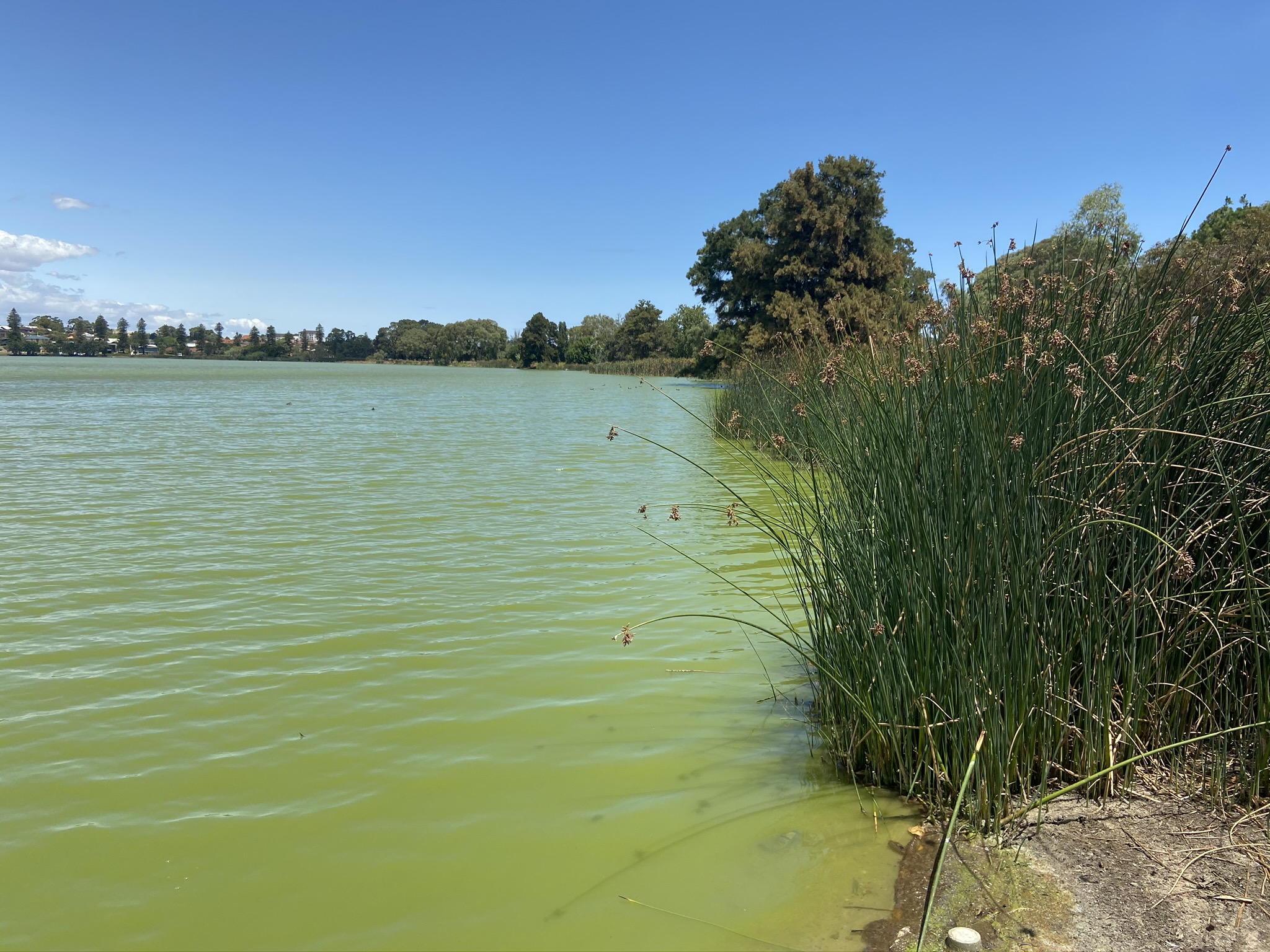
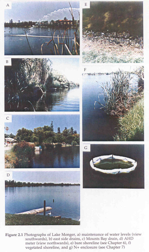
This article describes the location, history, physical, chemical and biotic factors of Lake Monger. The lake is a large urban wetland with high aesthetic and recreational values (Figure 2.1) (Middle, 1988), but poor water quality results from the effects of urbanisation. These effects have included physical modification, removal of fringing vegetation, the introduction of exotic biota, artificial regulation of water levels, pesticide treatments and nutrient enrichment. This has led to problems with nuisance midges (Chironomidae) (Davis et al., 1988), algal odour (Aplin, 1977), botulism outbreaks (Grubb, 1964; McRoberts, 1989), fish kills (Grubb, 1964; Bekle, 1981) and algal (Cyanobacteria) blooms. The severely degraded state but the high social value of the lake make it ideal for future restoration. The degradation of lakes reduces the overall complexity of processes within them allowing them to be more easily interpreted. This knowledge can then be applied to more complex and natural systems (Harris, 1969).
Location
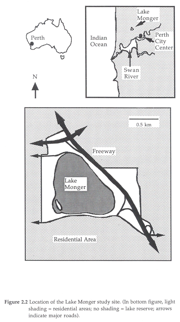
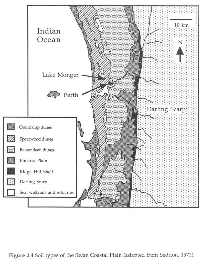
The lake (32o4’S 115o20’E) lies approximately 4 – 5 km from central Perth on the Swan Coastal Plain (Figures 2.2 and 2.3). Perth, with a population of approximately 1 million is the state capital of Western Australia. The Swan Coastal Plain is bordered by the Indian Ocean to the west, the Darling Scarp to the east, and extends approximately 100 km to the north and south of Perth (Seddon, 1972).

At Perth, the plain is approximately 30 km wide and is formed from sediments, unlike the igneous and metamorphic nature of the scarp. The plain is divisible into a series of systems that run parallel to the scarp. These are, from west to east; the aeolian Quindalup dunes, Spearwood dunes, Bassendean dunes and the alluvial Pinjarra plain and the Ridge Hill Shelf which make up the lateritic foothills of the scarp (Figure 2.4) (Seddon, 1972).
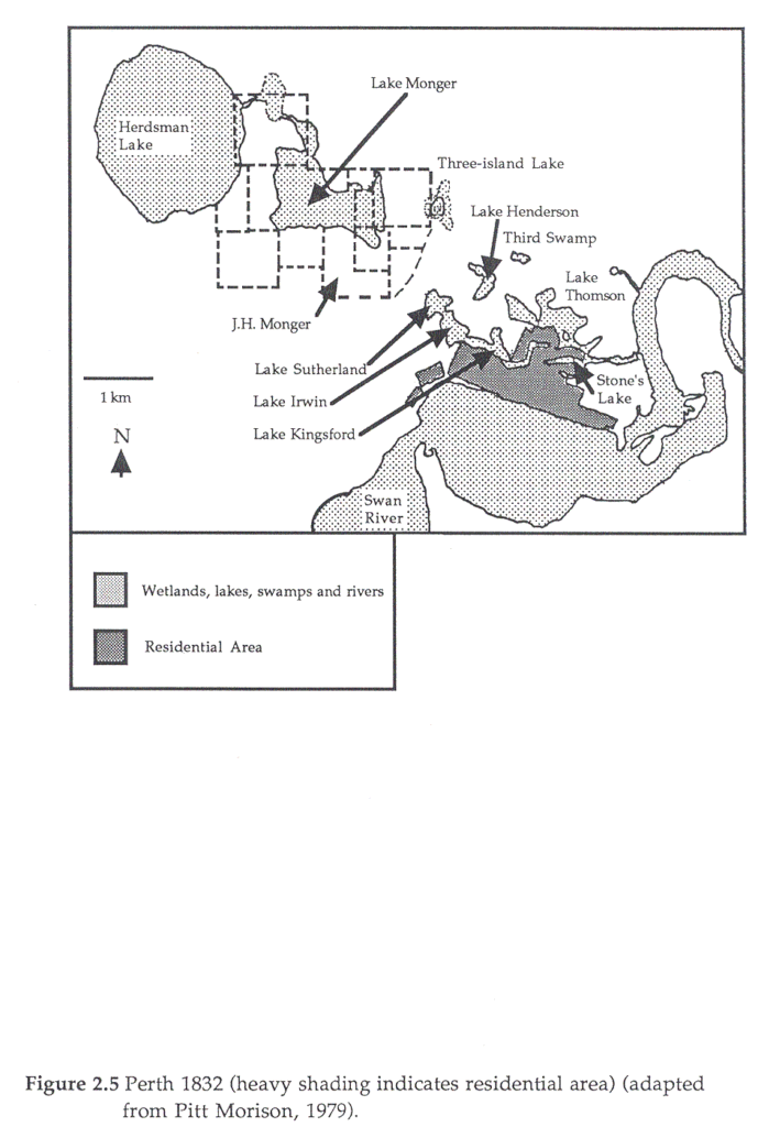
Lake Monger lies in the Spearwood dune system which is younger than the Bassendean dunes, but still of Pleistocene origin. This system has, as a result, typically higher hills and more fertile soils than the Bassendean dunes or the much younger Quindalup dunes. Rainwater permeating through ridges in the dune leaches calcium carbonate which re-solidifies in the centre of the ridge as limestone (Seddon, 1972). Between the limestone ridges are chains of lakes, which are “expressions of the unconfined aquifer above the ground surface and water levels vary in sympathy with the elevation of the water table” (Cargeeg et al., 1987). Lake Monger used to be part of a series of freshwater wetlands running northwards from the Swan River (Bekle, 1981). European settlement has led to the majority of these wetlands being drained. Indeed, central Perth is built on several drained wetlands (Figure 2.5). Riggert (1966) calculated that by 1964, 49% of wetlands on the coastal plain between the outer suburbs of Perth had been drained, filled or cleared. A recent estimate by Godfrey (1989) puts the loss at 80%.
Climate
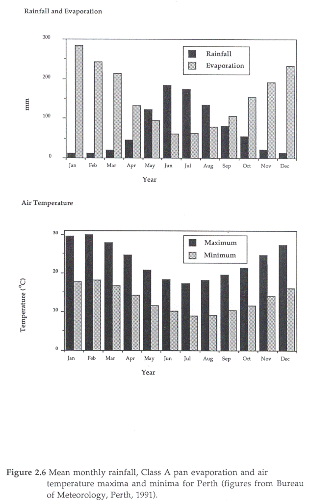
Perth has a Mediterranean-type climate, with hot dry summers and cool wet winters (Cargeeg et al.,1987). Rainfall between May and October accounts for about 90% of the total rainfall (Cargeeg et al., 1987). The annual average rainfall is 870 mm and Class A pan evaporation is 1819 mm (Cargeeg et al., 1987). Evaporation exceeds precipitation in all months except between May and August. Annual rainfall is variable from year to year, with extended periods of above or below average being common (e.g. between 1971 and 1987 only 4 years had average or above rainfall) (Cargeeg et al., 1987). Average air temperatures, rainfall and evaporation are shown in Figure 2.6.
History
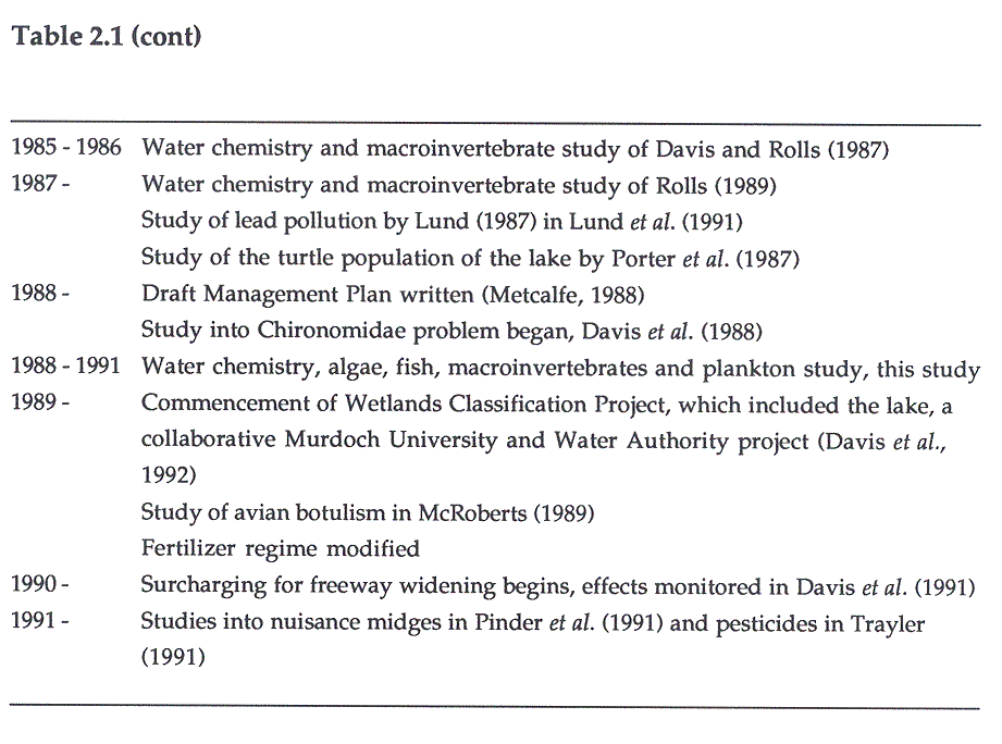
Perth was first settled by Europeans in 1829, although the area had been inhabited by aborigines for over forty thousand years (Spillman, 1985). A timeline of the history of Lake Monger is presented in Table 2.1.
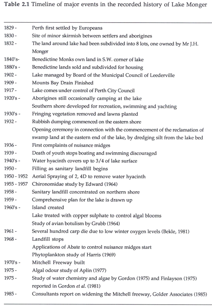
The lake first came to prominence as the site of a minor skirmish between soldiers and aborigines in 1830 (Miller, 1980). By 1832, the lands around the lake had been subdivided into eight lots; a southern one of 80 ha was owned by J.H. Monger. The name of the lake was eventually changed from Triangle Lake to Lake Monger after this early settler (Metcalfe, 1988). In the 1880’s several of the lots were subdivided for housing and by 1902 a board from the Municipal Council of Leederville had been appointed to manage the lake (Metcalfe, 1988). In 1909, the Mounts Bay Drain was completed connecting the lake and the Swan River and this allowed the water level to be regulated (Bekle, 1981; Metcalfe, 1988). In 1917, the lake came under the control of Perth City Council (Metcalfe, 1988). The lake and surrounding area were used by Aborigines as a camp, providing food from abundant waterfowl and from the surrounding rushes. Aborigines called the lake Galup and were still camping in the area up to the 1920s (Metcalfe, 1988). The lake has significance to Aborigines, who are likely to oppose any further physical disturbance of the lake. In the 1920s the lake’s southern shore was developed with a kiosk, bathing sheds (west side), boat house and a T-shaped jetty (Metcalfe, 1988). The lake was used for yachting, swimming, fishing and as a picnic spot, with areas of the lake being dredged to improve yachting (Miller, 1976). During the 1930’s much of the fringing vegetation was removed and replaced with lawns, as part of the reclamation of the eastern swampland. Reclamation was assisted by the dumping of rubbish (including raw sewage from nightsoil collectors) and dredging silt (Perth City Council, 1960) from the lake. By 1936 the effects of this began to be noticed with the first reports of nuisance midges (Bekle, 1981). The Depression saw the popularity of swimming and yachting peak, but the death of a youth in 1939 led to boating being forbidden and swimming being discouraged. Between 1950 and 1964, a 1.8 m deep sanitary landfill (domestic waste only) reclaimed 97 ha of wetland area. This was covered by 60 cm of soil as part of a lake beautification project in the north and north-eastern parts of the lake (Slattery, 1963). A comprehensive plan for the lake was drawn up in 1959, this saw the provision of land destined to become the Mitchell Freeway (built-in the 1970s) (Metcalfe, 1988). In 1912, the lake had an area of 111 ha, but by 1968 when sanitary landfill ceased, this had been reduced to 70 ha, its present size (Miller, 1980). An island was created during the 1960s in the southwestern corner as a bird refuge (Van Delft, 1988).
The lake is presently used extensively for recreation and is a major tourist attraction. Indeed, Middle (1988) suggested that in excess of 12 000 visitors per week visit the lake. He also found the most important activities were connected with birds (watching, feeding, photographing) and exercise.
Physical Features
The lake lies within a public park of 110 ha and has an area of 70 ha, within which is a small 1.3 ha island (Arnold, 1990). The lake originally used to dry up to a small pool during the summer (Metcalfe, 1988). The Mounts Bay drain has, since its completion, been used to regulate water depth in winter and in recent years the Perth City Council have maintained summer water levels by adding bore water. In 1909, the water depth varied from 1 to 4.27 m (Metcalfe, 1988). In the summers of 1955 – 57, the maximum water depth recorded was 2.44 m near the landfill site but the rest of the lake was approximately 0.9 m deep. In winter, depths rose 0.5 m until further increase was controlled by the overflow drain (Edward, 1964). In 1847, the water level was 13.3 m AHD (Australian Height Datum – height above sea level) (Bekle, 1981) and Arnold (1990) records maximum water levels of 13.43 m in 1976 and a minimum of 12.39 in 1972. At present, the sediment surface is calculated to be 11.7 m AHD. It is likely that the height of the lake bed has risen since European settlement, although dredging will have temporarily deepened some areas.
An east-west bottom profile in Lund et al., (1991) shows that the only significant changes in depth occur near drain outlets and within 5 m from the shore. They also found that organic matter levels in the sediment followed a similar pattern with an average of 37.0 ± 2.4% dry wt. across the lake bottom. However, within 5 m of the shore, organic matter levels drop to 1.4 ± 0.2% dry wt. as the sediment changes to sand. Edward (1964) found the lake sediment to be up to 3 m deep, consisting of three strata. The top layer (< 0.28 m) is very fine and flocculent and has up to 22 – 58% water (Perth City Council, unpublished data). The solid material appears to be mainly Chironomidae faecal pellets, and both algal and animal remains (Edward, 1964). In 1847 the lake bed was described as being too dense to use waders in (Bekle, 1981) presumably due to its softness. At present, the lake bed is too soft to wade through. The middle stratum is an approximately 0.3 m thick layer of coarse fibrous material which appears to be the remains of water hyacinth, and below this is a peat-like layer (Edward, 1964). The top layer has a neutral pH, while the other strata are slightly acidic.
Vertebrates
Fish
Miller (1980) describes the fish population of the lake in 1912 as containing English perch (Perca fluviatilis L.), tench (Tinca tinca L.) and carp (Cyprinus carpio L.). By the 1930’s bream (probably Silver Perch, Terapon bidyanus (Mitchell), see Scott, 1962) was also present (Bekle, 1981). The original native fish population of the lake is unknown but may have been limited to gobies (Pseudogobius olorum (Sauvage)) which survived in small pools when the lake virtually dried during summer. Edward (1964) records the presence of P. olorum (Glossogobius suppositus (sic)), Goldfish (Carassius sp) and the mosquitofish Gambusia holbrooki (Girard) (G. affinis (sic); see Lloyd and Tomasov, 1985; Wooten et al., 1988). Carp and then mosquitofish were introduced to control mosquitoes (Mees, 1977; Bekle, 1981). Mosquitofish are now possibly the most abundant fish in the southwest of Western Australia (Morrissey, 1978). Goldfish are believed to be unwanted aquarium fish (see Balla et al., 1985). Bream, tench and perch were probably introduced for improved fishing (Morrissey, 1978). At present, the lake contains P. fluviatilis (A. Pinder, pers. comm.), G. holbrooki, common carp (C. carpio) and Goldfish (Carassius auratus L.).
Birds
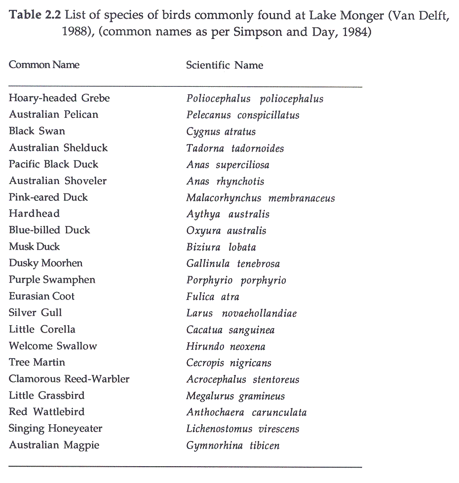
The birds commonly found on Lake Monger are given in Table 2.2. Bekle (1984) believed that many of the waterfowl roosted in Herdsman Lake as opposed to Lake Monger but commuted to the lake for feeding. Many waterfowl also nest in Herdsman Lake but when Herdsman begins to dry walk their young to the permanent waters of Lake Monger (Bekle, 1984). Feeding the swans and ducks has become a popular tradition amongst both tourists and locals; an estimated 50 loaves of bread are fed to the birds each day. This excessive feeding is believed to contribute to the prevalence of avian botulism in the summer months (Grubb, 1964; McRoberts, 1989; see Eccher, 1991). Although it is possible that some of the deaths attributed to botulism may be the effects of algal toxicity.
Amphibians and Reptiles
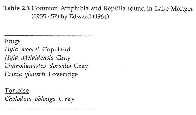
Edward (1964) lists some common amphibia and reptilia found at the lake (Table 2.3). The lake still supports a large population of Western long-necked tortoises (Chelodina oblonga), the biology of which has been studied by Porter et al. (1987) (cited in Main Roads Department, 1989). The tortoises were found to be significant predators of Chironomidae, ingesting an estimated total of 1000 kg of larvae per month.
Macroinvertebrates
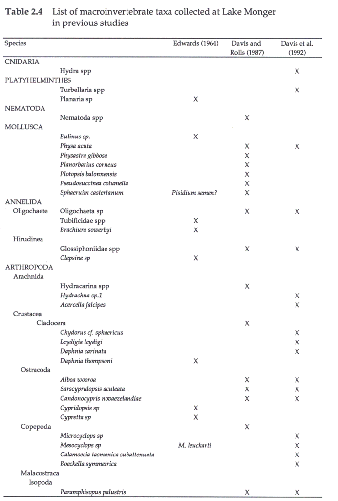
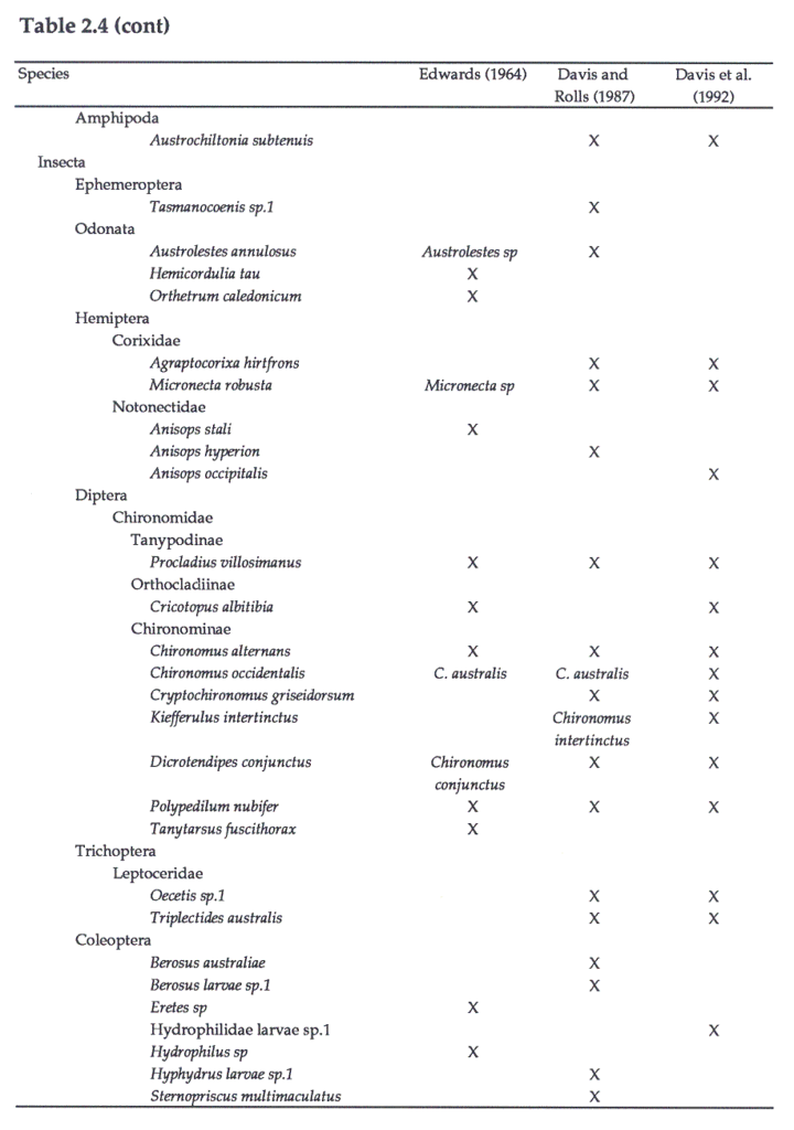
Edward (1964) lists some of the more common species of macroinvertebrates found within the lake during the 1950s. However, it was not until 1985 that the first detailed study of macroinvertebrates was undertaken by Davis and Rolls (1987) and Rolls (1989). They recorded a total of 40 species. The lake was sampled on 3 occasions between 1989 – 90, and a total of 35 species were recorded (Davis et al., 1992). A list of the species recorded in each study is given in Table 2.4.
The zooplankton of the lake has not been studied in any detail, although the Water Authority (W.A.) has counted zooplankton identified only to family level on several occasions between 1989 – 90. In November 1990, zooplankton identified to subfamily level were collected using activity traps as opposed to plankton tows (Trayler, 1991).
Vegetation
In the 1890s, introduced couch grass (Agropyron sp) had become established around the lake, probably from a nearby orphanage (Spillman, 1985). At this time the lake was described as being surrounded by large clumps of rushes and large trees (Spillman, 1985). The large trees were probably a mixture of Melaleuca rhaphiophylla (Swamp Paperbark), Eucalyptus rudis (Flooded Gum), Banksia littoralis (Swamp Banksia) and the common rush Typha orientalis Presl (Bekle, 1981; Bekle, 1984). In the 1920s and 30s much of this vegetation was removed and lawns were planted. In the 1950s Edward (1964) describes the water as having a brown colour, which is commonly associated with the presence of fringing vegetation (Wrigley et al., 1988). Edward (1964) and Harris (1969) describe the lake in the 1950s and 60s as having thick growths of Typha domingensis Pers (T. angustifolia (sic)) and Schoenoplectus validus Love (Scirpus lacustris (sic)) around the shore except at the northern tip and the southern shore. Edward (1964) also found the emergent Polygonum minus Huds. In 1970s, Gordon (1975) recorded the fringing vegetation as T. domingensis (T. angustifolia (sic)) and S. validus. Davis and Rolls (1987) recorded the emergent macrophytes T. orientalis and S. validus (Baumea articulata (sic)). In this study, S. validus and T. orientalis were the dominant emergent macrophytes, Polygonum decipiens R. Br. was present in low numbers. None of the paperbarks or banksias remains around the lake and stands of Agropyron sp and T. orientalis form the bulk of the fringing vegetation, especially on the eastern side.
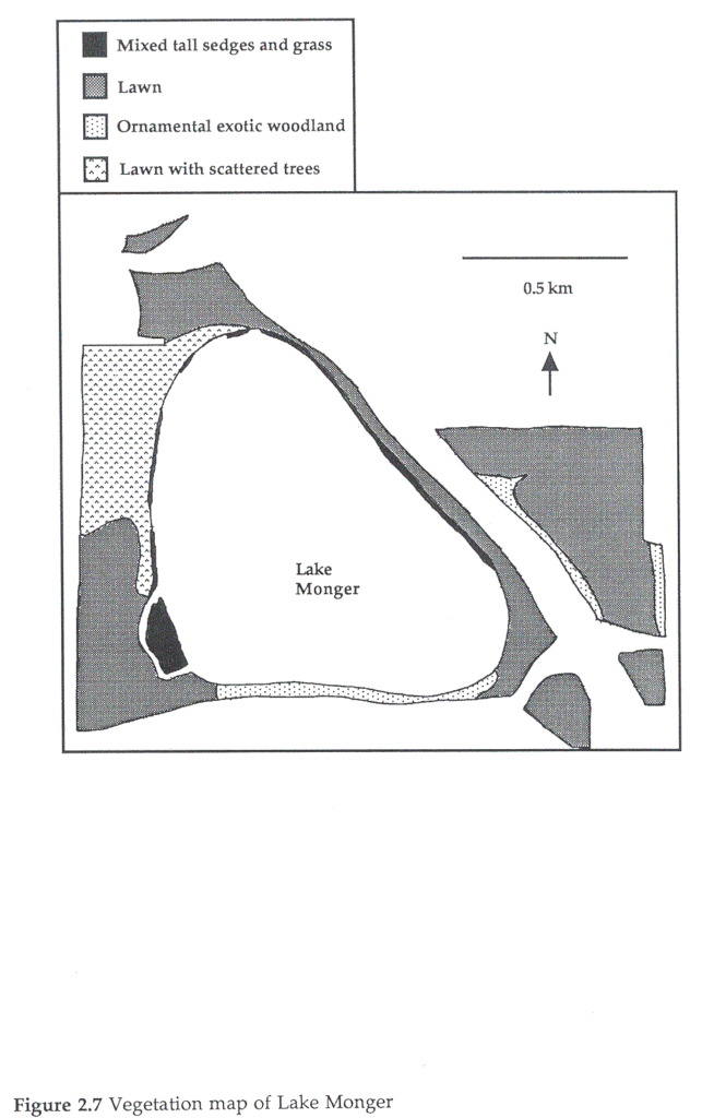
Water hyacinth (Eichhornia crassipes Solms) was introduced into the lake, prior to 1920 (Miller, 1976) and had by the 1940s covered almost 3/4 of the water (Edward, 1964). Between 1950 – 1952, aerial spraying with 2, 4D herbicide eliminated most of the hyacinth, banksias, paperbarks and reeds (Perth City Council, unpublished data). Edward (1964) recorded a small number of water hyacinth plants between 1955 – 57 but none remain now. He also found the floating macrophyte Spirodella oligorrhiza Hegelm. Harris (1969) found the submerged macrophyte Potamogeton pectinatus L. and noted that the sediments were covered at various times of the year by the algae Cladophora sp and Spirogyra sp. Lund et al. (1991) also recorded Cladophora sp. and in this study dense stands of Oedogonium sp were noted in spring. In this study, a few plants of Potamogeton crispus L. were collected in November 1988. The current distribution of vegetation around the lake is shown in Figure 2.7.
Algae
The algal composition of Lake Monger is presented in Table 2.5. Edward (1964) only noted some of the more common forms between 1955 – 57, but Harris (1969) made a detailed study of phytoplankton ecology between 1968 – 69 and recorded 29 species. At this time Perth City Council tried unsuccessfully to control blooms of Anabaena spiroides Klebahn using copper sulphate (15 000 kg were added in February 1969) (Harris, 1969). Gordon et al. (1981) recorded 43 species in 1975, but unfortunately only listed the most common ones (Gordon, 1975; Finlayson, 1975). Aplin (1977) only recorded counts for three species in a 1975 study of algal odour; no odours were noted during the study. Davis et al. (1992) conducted algal counts on several occasions between 1989 – 90 but recorded relatively few species. Several general trends emerge from all the studies; the Cyanobacteria (especially Microcystis aeruguinosa Kutz) are dominant in summer, with green algae becoming dominant during winter. All studies have reported substantial improvements in water quality during winter.
Nutrient and Water Balance
No nutrient or water balance has been determined for the lake. Twenty-three drains enter the lake. Three are Main Roads Department drains from the freeway and one is a Water Authority of Western Australia (WAWA) drain. The remainder are Perth City Council drains (Figure 2.8). Only one drain carries water from the lake, the Mounts Bay drain (controlled by WAWA). The total catchment of the lake is 597.8 ha, covering mainly residential areas. Water enters the lake from three sources, surface runoff through the drains, rainfall and from groundwater, and leaves via groundwater, evaporation and through the Mounts Bay drain.
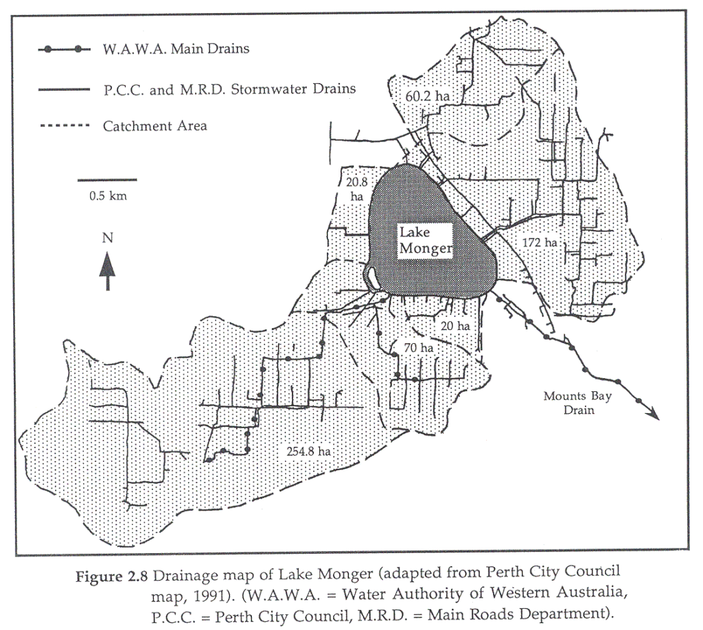
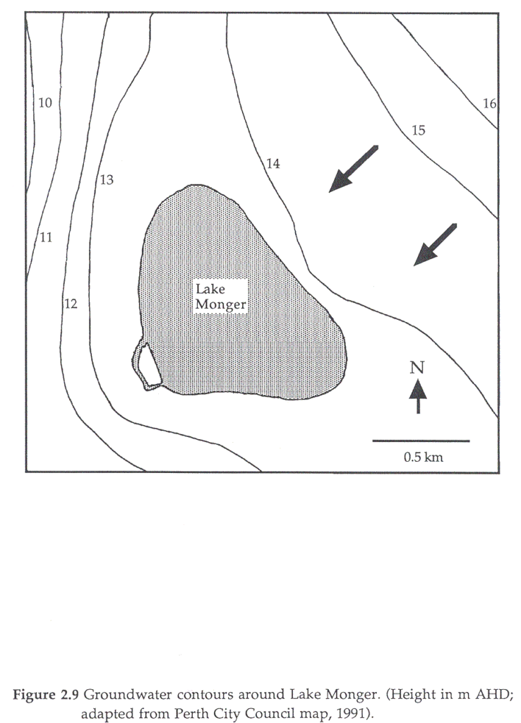
Groundwater is the hardest component to quantify. Bayley et al. (1989) for North Lake (Western Australia) (area 27 ha, depth, 2 – 3 m) found that groundwater contributed 29% of the water, 20% of total phosphorus and 26% of total nitrogen input into the lake between 1987 – 88. Groundwater outflow accounted for only 17% of the water output. This was approximately half the input water volume and carried half the input phosphorus load and double the nitrogen load. The remainder of the input was made up by surface inputs. A similar pattern was also found for the water balance of Lake Joondalup (Western Australia) (Congdon,1985). It appears likely that the water balance of Lake Monger is similar to these two lakes as they are all situated on the same soil type and have similar origins. In summer, the groundwater in the sediments of Lake Monger had higher concentrations of phosphate and ammonia, and lower concentrations of nitrate, sulphate, chloride, sodium, calcium and magnesium than the lake water (Davis et al., 1991). These findings were believed to be typical of anoxic waters with some leachate contamination. The groundwater flows in a south-westerly direction across the lake (Figure 2.9). It is, therefore, likely that groundwater is adding to the nutrient loading of the lake, bringing in leachate from the sanitary landfill and nutrients from the urban catchment. It is also likely that only a small proportion of the nutrient load entering the lake is lost through groundwater outflow, although a larger proportion may be lost through the outflow drain. Considering the large numbers of drains entering the lake, the greatest contribution to both the nutrient load and water inflow probably occurs through the drains.
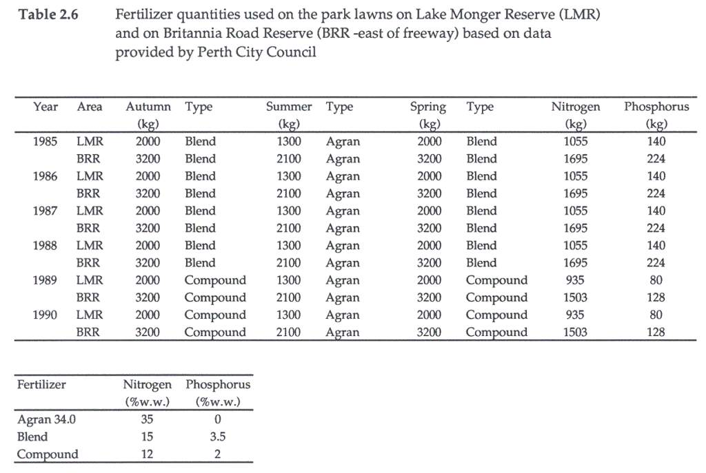
Surface runoff from surrounding urban areas and the freeway was believed to have polluted the lake sediments with lead (Lund et al., 1991) and nutrients (Davis and Rolls, 1987; Metcalfe, 1988). The source of nutrients appears to be applications of fertilizer to domestic and park gardens (Metcalfe, 1988). Since 1988, changes have been made to the fertilizing regime used by Perth City Council on the park lawns. This was done to reduce pollution from this source (Table 2.6). The sandy soils around the lake have a very low capacity to retain nutrients (Alexander, 1988) and therefore much of the fertilizer will enter the lake through the groundwater or surface runoff. Water quality data for the lake have been reported in Edward (1964), Harris (1969), Aplin (1977), Gordon et al. (1981) (taken from Gordon (1975) and Finlayson (1975)), Davis and Rolls (1987), Rolls (1989), Davis et al. (1988), Davis et al. (1991a), Pinder et al. (1991) and Davis et al. (1992).
References
Alexander, I. (1988) Report of the Select Committee to the Legislative Assembly on effluent disposal in the Perth metropolitan region. State Government of Western Australia, Western Australia.
Aplin, T.E.H. (1977) Report of the algae odour control working group. Department of Conservation and Environment, Western Australia.
Arnold, J. (1990) Perth wetlands – A resource handbook. Environmental Protection Authority and Water Authority of Western Australia, Western Australia, Bulletin 266
Balla, S.A., Lloyd, L.N. and Pierce, B.E. (1985) Unwanted aquarium fishes. Search, 16, 300-301.
Bayley, P., Deeley, D.M., Humphries, R. and Bott, G. (1989) Nutrient loading and eutrophication of North Lake, Western Australia. Environmental Protection Authority, Western Australia, Technical Series 33.
Bekle, H. (1981) The wetlands lost: Drainage of the Perth lake systems. Western Geographer, 5, 21-39.
Bekle, H. (1984) A comparative review of lakes in the Perth metropolitan area. Western Geographer, 8, 61-77.
Cargeeg, G.C., Boughton, G.N., Townley, L.R., Smith, G.R., Appleyard, S.J. and Smith, R.A. (1987) Perth urban water balance study. Volume 1: Findings. Water Authority of Western Australia, Western Australia.
Congdon, R.A. (1985) The water balance of Lake Joondalup. Department of Conservation and Environment, Western Australia, Bulletin 183.
Davis, G.B., Barber, C., Briegel, D., Lambert, M. and Hosking, J. (1991a) Water quality changes at Lake Monger due to widening of the Mitchell freeway. CSIRO, Western Australia, Progress report for the Main Roads Department.
Davis, J.A., Harrington, S.A. and Pinder, A.M. (1988) Investigations into more effective control of nuisance chironomids (midges) in metropolitan wetlands, Perth, Western Australia. Murdoch University, Western Australia.
Davis, J.A., Rolls, S.W. and Balla, S.A. (1987) The role of the Odonata and aquatic Coleoptera as indicators of environmental quality in wetlands. In: The role of invertebrates in conservation and biological survey (Ed. J.D. Majer), pp. 31-42. Department of Conservation and Land Management, Western Australia.
Davis, J.A., Rosich, R.S., Bradley, J.S., Growns, J.E., Schmidt, L.G. and Cheal, F. (1992) Wetland classification on the basis of water quality and invertebrate community data. A report to the Australian Water Resources Advisory Council, Water Authority of Western Australia and Environmental Protection Agency of Western Australia, Western Australia.
Eccher, C.J. (1991) Please please don’t feed the ducks. Lake Line (Alachua: Florida), 2, 25.
Edward, D.H.D. (1964) The biology and taxonomy of the Chironomidae of south-western Australia. Ph.D thesis, University of Western Australia, Western Australia.
Finlayson, C.M. (1975) Nitrogen in wetlands. Honours thesis, University of Western Australia, Western Australia.
Godfrey, N. (1989) The value of wetlands. In: Wetlands in crisis. What can Local Government do? (Ed. Anon), pp. 4-12. Environmental Protection Agency, Western Australia.
Gordon, D.M. (1975) Studies on the relationship between phytoplankton productivity and phosphorus in three shallow freshwater lakes. Honours thesis, University of Western Australia, Western Australia.
Gordon, D.M., Finlayson, C.M. and McComb, A.J. (1981) Nutrients and phytoplankton in three shallow freshwater lakes of different trophic status in Western Australia. Australian Journal of Marine and Freshwater Research, 32, 541-553.
Grubb, W.B. (1964) Avian botulism in Western Australia. Australian Journal of Experimental Biology, 42, 17-26.
Harris, P.L. (1969) Phytoplankton ecology of Lake Monger (North Perth). Honours thesis, University of Western Australia, Western Australia.
Lloyd, L.N. and Tomasov, J.F. (1985) Taxonomic status of the mosquitofish, Gambusia affinis (Poeciliidae), in Australia. Australian Journal of Marine and Freshwater Research, 36, 447-451.
Lund, M.A. and Chester, E.T. (1991) The use of aluminium sulphate to control algal blooms and chironomids in Jackadder Lake, Western Australia. Verhandlungen der Internationalen Vereinigung fur Theoretische und Angewandte Limnologie, 24, 1129-1133.
Main Roads Department (1989) Landfill for future widening of the Mitchell Freeway at Lake Monger. Main Roads Department, Western Australia, Public Environmental Review.
McRoberts, K. (1989) Investigation of avian botulism in an Australian urban wetland. Honours thesis, Murdoch University, Western Australia.
Mees, G.F. (1977) The status of Gambusia affinis (Baird and Girard) in south-western Australia. Records of the West Australian Museum, 6, 27-31.
Metcalfe, V.J. (1988) Development and management plan for Lake Monger. City of Perth, Western Australia,
Middle, G.J. (1988) A method to evaluate conservational and social value of lentic wetlands on the Swan Coastal Plain. Honours thesis, Murdoch University, Western Australia.
Miller, C. (1976) Old Battleground. Living Today (Western Australia), January 29, 32-33.
Miller, C. (1980) After summer merrily. Fremantle Arts Centre Press, Fremantle.
Morrissey, N.M. (1978) The past and present distribution of marron, Cherax tenuimanus (Smith), on Western Australia. Fisheries Research Bulletin (Western Australia), 22, 1-38.
Perth City Council (1960) Municipal Yearbook 1960. Perth City Council, Western Australia.
Pinder, A.M.,Trayler, K.M. and Davis, J.A. (1991) Chironomid control in Perth wetlands. Final Report and recommendations. Murdoch University, Western Australia.
Porter, B., Dunlop, J.N. and Clay, B. (1987) Mitchell Freeway Stage III Fauna survey and tortoise study. Main Roads Department, Western Australia, Informal Interim Report.
Riggert, T.L. (1966) A study of the wetlands of the Swan Coastal Plain. Department of Fisheries and Fauna, Western Australia.
Rolls, S.W. (1989) The potential of North Hemisphere biotic indices as indicators of water quality in wetlands on the Swan Coastal Plain, Western Australia. Honours thesis, Murdoch University, Western Australia.
Seddon, G. (1972) Sense of place. University of Western Australia Press, Western Australia.
Slattery, J.F. (1963) Report on refuse disposal in Perth 1958-62. Public Health Department. Western Australia
Spillman, K. (1985) Identity prized. A history of Subiaco. University of Western Australia, Western Australia.
Trayler, K.M. (1991) Impact of potential chironomid (Diptera: Chironomidae) control agent, pyriproxyfen (S-31183), on indigenous non-target aquatic organisms. Honours thesis, Murdoch University, Western Australia.
Van Delft, R. (1988) Birding sites around Perth. University of Western Australia Press, Nedlands.
Wooten, M.C., Scibner, K.T. and Smith, M.H. (1988) Genetic variability and systematics of Gambusia in the southeastern United States. Copeia, 1988, 283-289.
Wrigley, T.J., Chambers, J.M. and McComb, A.J. (1988) Nutrient and gilvin levels in waters of coastal-plain wetlands in an agricultural area of Western Australia. Australian Journal of Marine and Freshwater Research, 39, 685-694.